Sunday 19 May 2013

Lower Mainland Eaglet League


We've all seen how folk, shortly after graduating, drift away from the sport due to a myriad of reasons - frustration with slowing skill development, lack of engagement by peers, loss of perceived challenge. All of these factors contribute to new pilots exiting the sport or, worse yet, becoming once a year pilots with next to no currency and a decaying skill set.

Experience has shown that having a competition oriented goal can help a pilot not only get out and fly but fly with a focus on improving - building skills and maintaining currency. The challenge with the current brand of paragliding competition is that it is mostly geared towards experienced XC capable pilots (Intermediate and above) flying higher end (EN C and above) wings. This inability to engage pilots earlier in their careers has been flagged as a contributing factor in falling competition participation.

Enter the Eaglet League. With a motto of 'Growing with every flight' (and help from JetSet Paragliding and Thermal Addict Air Sports), its purpose is to take a step back from the typical XC league format and encourage new pilots (Novice/P-2) on beginner/intermediate wings (EN-A/B) to build the skills that will allow them to grow into XC flying. The goals are smaller, bite size chunks to help encourage pilots to fly new sites, try to climb higher, fly longer, even recognizing that one in a million low save.

The rules and awards can be found at: http://www.jetsetparagliding.com/bragging-rights.html

If you are a Novice/P-2 flying an EN-A/B wing in the WCSC region, you are our kind of pilot.


Tuesday 14 May 2013

IPPI: The International Drivers License for Paraglider Pilots

The Card

The International Pilot Proficiency Information (IPPI) system is a means for a national association (and its member pilots) to map their ratings system against a common international standard, allowing paraglider and hang glider pilots to travel and not have to worry about qualifying for country specific ratings.

The mapping of ratings to IPPI is done by the national association against a skills index set out by the Federation Aeronautique Internationale (FAI). The IPPI skills index and resultant ratings can be thought of as a lowest common denominator for the progressive stages of development within a pilots career.

IPPI comes in 5 stages, with 1 being the lowest rating and 5 being the highest.

1. Ground Skimming.
2. Low Level Flight.
3. Soaring in Non-Turbulent Conditions.
4. Soaring in Turbulent Conditions.
5. Cross Country Flight.

A pilot wishing to travel and make use of the IPPI system needs only to contact their national association and request the card (and likely pay a fee).

The association will issue a card with one or both endorsements, SafePro for hang glider pilots and ParaPro for paraglider pilots.


The IPPI card never expires and only requires replacement when a new rating is obtained.
But note that the IPPI card is invalid if not paired with a valid membership from the issuing national association. So while the IPPI card will never expire, an expired membership can and will render the IPPI card invalid.

A pilot planning to travel will quickly realize that the requirements for visiting pilots in any given country will vary greatly. Some countries, such as France, have no specific requirements, while others, such as Switzerland, have stringent ones. There are even site specific requirements. It would be prudent to research where one is planning to fly ahead of time to be aware of what restrictions, if any, exist.

Country specific requirements can be found here.

HPAC vs. USHPA

Remembering that the IPPI system is a lowest common denominator and that ratings vary from country to country, a pilot with membership in more than one national association can maximize their IPPI rating with a little research (rating 'arbitrage', if you will).

The HPAC Dilemma

HPAC's mapping to IPPI is as follows:

1. Ground Skimming -> Student.
2. Low Level Flight -> Novice.
3. Soaring in Non-Turbulent Conditions -> Intermediate + HAGAR (Hang Glider Air Regulations).
4. Soaring in Turbulent Conditions -> Advanced + HAGAR
5. Cross Country Flight -> Master & Advanced + HAGAR.

Given that most countries that require IPPI, require a minimum of IPPI 4 to be able to fly - it becomes readily apparent that one is not doing a lot of travelling before obtaining their HPAC Advanced Rating, if they wish not to fly 'below the radar'.

Also of note, most of the post graduate training courses offered in Europe in English are taught by British Hang Gliding and Paragliding Association (BHPA) instructors.  The BHPA awards an IPPI 3 for their Novice equivalent rating (Club Pilot - CP) and these instructors require it, even to teach basic thermalling to a non-student pilot. A member of HPAC would require their Intermediate (150 flights/25 hours) + the HAGAR endorsement to avail themselves of even these most basic courses.

USHPA to the rescue (somewhat)

A little research turned up that another option exists for Canadian pilots who hold a membership in the United States Hang gliding and Paragliding Association (USHPA).

The USHPA mappings are as follows:

1. Ground Skimming -> P1.
2. Low Level Flight -> P2.
3. Soaring in Non-Turbulent Conditions -> P3 + 5 sites.
4. Soaring in Turbulent Conditions -> P4 OR P3 + TUR
5. Cross Country Flight -> P4 + XC.

The IPPI 3 and 4 ratings are of interest in this case, as the USHPA P3 only requires 90 flights and 20 hours airtime. A Turbulence (TUR) skill sign off would be required for IPPI4, but would be easily acquired by a P3 candidate with mountain flying experience. IPPI 3 with two-thirds the flights and no HAGAR exam and IPPI 4 with half the flights, one fifth the hours, and no HAGAR exam.

The downside of this approach for Canadian pilots is the additional cost of an USHPA membership, but as most Canadian pilots fly Stateside and hold a membership anyways, there would be little cost to utilizing USHPA for IPPI3 and 4 over HPAC.


Summary


IPPI: HPAC vs. USHPA Requirements
IPPI Rating HPAC Requirements USHPA Requirements
1 12 mins 4 flights
2 35 flights/4 hours 25 flights
3 150 flights/25 hours/HAGAR 90 flights/20 hours/5 sites
4 200 flights/100 hours/HAGAR 90 flights/20 hours/TUR
5 200 flights/100 hours/HAGAR 250 flights/75 hours/XC

Sunday 5 May 2013

Atmospheric Soundings: Gaining a Clearer Picture

Tools

Amongst the myriad of tools a paragliding pilot has at their disposal, few rank higher in importance than those used to assess the ever changing weather picture and forecast soaring conditions. The ability of a pilot to pull in macro weather data and map it against terrain features, thereby generating a micro forecast, can make a huge difference in ease of soaring and XC.

We have all heard the recounted exploits of the local 'sky gods' (and goddesses) over a post flying day beer, marvelling at how they always seem to be in the right place at the right time to capture that elusive lift. Much of this is the result of a mental model refined over years of flying experience, but in many cases it is also the result of knowing the right tools to fit with that model. An atmospheric sounding is (potentially) one of those tools.

The Sounding Graph

The sounding graph contains a vast amount of information which a pilot can use to formulate a detailed picture of atmospheric conditions. But before we start delving into what can be gleamed from this graph, we must understand how it is laid out.


Time


The time/date used in the sounding graph is based in Coordinated Universal Time (UTC), which for our purposes is nothing more than the newfangled way of saying Greenwich Mean Time (GMT).

UTC is can be found in a 4 digit format (with the right most pair of digits representing minutes and the remainder representing hours), or a 2 digit one (hours only). The sounding does not resolve to the minute, so a 2 digit time format is used. 

The hours in UTC are based upon a 24 hour clock, with 0 representing midnight and 12 (or 1200 in a 4 digit format) representing noon. 


During daylight savings time, subtract 7 hours to arrive at local British Columbia Time (PST) from UTC. Otherwise, subtract 8 hours.

The sounding above is for 1500 hrs, May 5, 2013 UTC (8AM PST, May 5, 2013).

Location


The location for which the sounding is considered valid is presented in a longitude/latitude decimal format. West longitudes are negative, as are south latitudes. The sounding above is for 121.99 degrees West longitude, 49.14 degrees North latitude, the Mount Woodside launch near Agassiz, BC, Canada.

Wind


Wind speed and direction are displayed to the right of the graph as a series of altitude dependant barbs.
The spine of the barb is the direction from which the wind is coming. The vanes extending from the spine represent a cumulative sustained speed. Wind speed is measured in knots. A circle with no spine or vanes represents nil/calm/0 knot wind. The blue line vertically traversing the barbs gives a quick indication of wind speed changes versus altitude (with 50 and 100 knot demarcations).


Pressure


The vertical scale along the left side of the graph is the air pressure, measured in hectopascals (hPa). 1000 hPa can be thought of as the air pressure typically found at sea level, while 0 hPa would be perfect vacuum.

Any point found along a line travelling horizontally from the pressure scale is isobaric, the same pressure. This line is frequently referred to as an isobar.

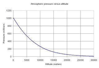
The pressure value decreases as one ascends through the atmosphere, though it is not a linear relationship with altitude. The relationship is in fact logarithmic in nature - with absolute pressure falling off rapidly at higher altitudes. 


1 millibar = 1 hPa.

Opposite to the pressure is the mapping to altitude in feet. The mapping of pressure to altitude will change as weather systems move through a region and create variations in the sea level air pressure.


The pressure component of a sounding is frequently referred to as a Log P.

Temperature


Running across the base of the sounding is the air temperature, measured in degrees Celsius (C). Of note is that fact that the graph lines for temperature do note rise straight upwards as is found in typical X vs. Y graphs, but rise at a roughly 45 degree slope from lower left to upper right. Any point along this 'skewed' line is isothermic, the same temperature. This line is frequently referred to as an isotherm.


The temperature component of a sounding is typically referred to as a Skew-T.

What about the other lines and how can I put this to use?

That my friend, is the topic of the next posting. What sort of blog would this be if it didn't end with a cliff hanger once in a while?