Showing posts with label Gin Explorer. Show all posts

Tuesday, 21 March 2017

A Paragliding Personal Best (PB): Part 1

Note: The FlyinOrange has moved to: flyinorange.blog

Day 6 (Thursday): Overdevelopment shuts the day down. Only Richard launches and spends the majority of the flight trying to avoid being hoovered up into the stratosphere by the towering Cu that has set up shop over the mountain.

Day 7 (Friday): A botched initial climb out leads to my sliding off the mountain and setting down in 'Jurassic Park' (the bomb out at the foot of the mountain). A break down in comms on my end leads to some confusion over the retrieve picture. The end result: my electing to hike back to the hotel in GV.

35 C.
2.5 hours.
10 kgs of kit.

The decision to go lightweight pays dividends during this and subsequent hike outs.

Day 8 (Saturday): Perchance two bad days makes for a good one?

The Brazilian Cross Country (XC) league is holding the latest in their year long XC contest here in GV. We were told to expect 93 pilots to attend this event so things might get cozy in the air. Thankfully the comp organizers are not going to close the launch meaning we don't have to race to get ready and launch ahead of the main comp group. On top of this we get word that we can also expect a contingent of 20+ Norwegians to arrive for a XC course of their own. Rumour has it that the course is mandatory for these pilots to be deemed XC ready and given an endorsement by their National Association Committee (NAC). Is that a cash register ringing in the background?

Comp pilots setting up.

In amongst the hustle and bustle of the comp Dean gathers us up and lays out the plan for the day, an out and return (Dean's favourite - to save on the need for retrieve, I gather). The turn around point will be Engenheiro Caldas again (hopefully not blocked by growing overdevelopment/storms this time). The wind today is straight east (rather than the hoped for NE tail) which means a cross/tail component on the way out and a cross/head component on return. My personal preference would be for a straight SE run with no return leg - simply maximize distance with what little tail wind component we have. But it is not to be.

Rob (the second in air guide/instructor joining Dean this year due to the sheer size of the group) syncs up with me for a quick discussion regarding the flight - if I am able to keep up with Dean's group, go for it. Otherwise Rob will be hanging back to provide in air coaching as needed to stragglers.

Ready to go.

We get the crew in the air in record time (word has it afterwords that from first to last it took less than 7 minutes to get 12 pilots plus 2 guides off).

I quickly join Simon in snagging a climb just out front of the Cauldron.

Still giving this beast a wide berth.
Above launch but with everything shaded over, time to head for a sunnier spot.

While successful in getting above launch, the climb dissipates. I need to find terrain that is still receiving sun. The west side of the mountain looks to have just what I need (and will put me closer to the XC jumping off point - the hill to the west nicknamed 'Salvation').

Baking in the sun, this terrain is a good thermal generator.
These thermals will hug/craw along the terrain until a trigger point further up the mountain slope.

Thermal hunting.
Found it! Climbing anew.
Time to push on to Salvation.

Further away from the mountain another climb to top up and push onto 'Salvation' ahead.
About as textbook as it gets.
The source: sun baked fields and quarry.
The trigger: 'Salvation'.
The sign: the cloud.
Salvation delivers.

Climbing over 'Salvation'. GV ahead/below.
Onwards SE we go ...

How will today unfold?

Wednesday, 15 March 2017

Day 5: A flight cut short.

First day in Governador Valadares. The main reason why most pilots come to Brazil is to fly here and to fly far (the second location is Quixada to the distant northeast, though only select few can and do fly there).

The launch is on the lone mountain in the region, Ibituruna. At 1100 meters and surrounded by a near endless expanse of rolling hills to the south - it is the perfect place for the intermediate pilot to start building upon their flatland flying skill set.

For the solo pilot not booked into a tour, retrieve is simply a matter of catching the blue/red/white Rio Doce bus that runs up and down BR116 every hour or two - though many a local will stop and offer rides with little to no expectation of repayment (though this is starting to change so I hear - word is spreading that visiting pilots are a lucrative cash cow). Rides up the mountain can be found at the main LZ near the river - having some knowledge of Portuguese will help immensely in this regard (otherwise it is a pricey cab ride up the hill).

This being the first day in GV, Dean wants to limit the ambition level of the task. An out and return to Engenheiro Caldas is the plan.

I kit up quickly and launch with the first third of the group, including Dean. Putting to use lessons learned from flying here last year, I immediately fly to the lip of the Cauldron hoping to catch some lift that is being pushed up the slope by the easterly wind.

Working the eastern edge of the Cauldron.

The climb takes me above launch height, but it is slow going. Over the radio I hear Dean, "Ok lads, let's get going."

I need a stronger/faster climb, I need what is boiling on the rock face.

Skirting the Cauldron, I work my way around to the western edge.

Motoring along in search of a stronger climb that is sure to be downwind of this thermal generator.
Almost there - wing still well behaved.

Turn in and head south to intersect any Cauldron born thermals being blown by the wind.

Southwards I venture. In the meantime, Dean is now over the hill to the west nicknamed 'Salvation' (aka the 'Crocodile' due to its shape). Salvation is a common second climb out point for pilots hoping to fly cross country (XC) to the south east (which follows BR116) towards Caratinga, 100 km away.

I still need more height if I am to transition to Salvation and join up with Dean. Not much is found downwind of the Cauldron which means I will need to hug onto the slope and hope to catch a 'crawler' thermal, sliding up to a trigger point along one of the many ridges fanning out from the mountain.

Change in plans. Move in closer.

Time to get a little cozy with the hill.

A few beats back and forth. Little concern of sinking out - this tactic has worked countless times in the past, simply a matter of being willing to kick tree tops.

The mountain delivers. Back above launch and still climbing.

Next stop, Salvation.

Salvation bound.

Have a wee bit of altitude to make up.

Working a climb.

Dean is still climbing out over this hill, so there is a chance I can still join up with he, Richard, and Simon.

Joining Simon in the climb.
Over the radio I hear, "Ok Mark and Simon, lets go." Gather Dean figures we have enough altitude to make the next jump. Topping up as needed, we push southwards along the road.

And another climb.


Passing Alpercata, Richard and I sync up. Working the climbs together, we continue onwards south with Dean well in the lead.

The kilometer tall mountain off in the distance.
Nearing the half way point towards Engenheiro, Dean pipes on the radio, "I'm not liking the look of those clouds to the south". Richard replies,"Yes. Looks like Death and Destruction.".

Richard and I continue on.

One of countless low saves this trip.

A few minutes pass, Dean on the radio, "I think we should turn back. It might be ok, but I'd rather not chance it."

Looking ahead to the south, I am one to agree.

A dark and humid sky awaits to the south.

Dean on the radio, "Mark, what are your thoughts?" (aka you are going to do what I suggest, yes?)

"Death and destruction. Cats and dogs living together. Understood. Turning back."

"Heh."

I begin the return leg and make it back to a hillside between the two gas stations along the road.

Packed up and awaiting retrieve, I look up to see this:

Would say landing was the right call.

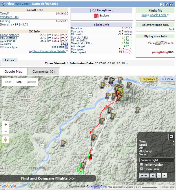
The flight.

Survived to fly another day. Los Hermanos for dinner.

Fly. Eat. Sleep. Repeat.
It gets better ...

Friday, 10 March 2017

Flying amongst Condensation Castles:Part 2

I give chase to the gaggle proceeding northwards.

Dean is but a spec, high in the distance with a train of gliders stung out behind. I get strong sense Dean is very much about flying fast - maximize time on glide, minimize time in climbs. Simply put, one does not rack up the km's going around in circles. Take risks, calculated ones mind you. In some ways it feels to be the antithesis of comp flying where one lets the gaggle do most of the work and flying conservative (until final glide) almost always pays off. In essence - comp flying is fixed distance vs. near unlimited time (relative to the distance), while XC is fixed time (sunset) vs. unlimited distance. A lot of overlap in skill, but differing in mindset.

A satori of sorts but there is still flying to be done.

The crew push on northwards. Landing options are more limited with restricted retrieve possibility. Bushwacking in 37C temps on my second day of flying here? Not so keen. And I am getting low again.

I need a top up. So back south to the ridge face overlooking the valley. I am sure to snag something there.

A Nova Phantom sharing the same plan.

Heading south, into wind.
Trying to avoid the venturi that is sure to be between the two hill tops at the bottom of the picture.


Climbing again.


Another climb scored.

It is unlikely I will be able to link up with Dean and the others at this point, so I branch off on my own to give the run to town a look.

Castelo ahead. Tick Hill LZ to its left. Wall LZ directly below.

Unless I find another climb, the Tick Hill LZ (so named due to the tick infested long grass covering it) is a gamble with the growing sea breeze (one needs to arrive rather high at LZs here in Brazil due to the potential for power lines). The Wall LZ is possible but will put me further from the retrieve van with its AC (thus a longer wait for no real benefit). 

Lets make the best of the situation and turn this straight line run into a triangle. Backtrack towards launch and try for an into wind valley crossing.


Motoring on back up the valley.
See the perfect crossing point ahead? Good. Cause I didn't.

If there is ever a master of the low save, you're lookin' at 'em right here (I've since been given the nickname 'ain't no thermal low enough' by my fellow tour mates). So I gamble on driving straight out in the valley with the intent of catching enough bubbles to make the opposite ridge line.

Rolling the dice.

Bubbles are found, but not quite enough. Eventually I roll snake eyes and need to find a LZ.

One final pass, looking for power lines.

LZ located. A side hill landing (crash) it will be.

Sadly, Little Baby Jesus did not smile on my attempt at a valley crossing today.
On final...
... and down.


 Landed nary a scratch or bruise (it goes 50/50 in my case with remote side hill landings). Radio in on the retrieve channel that I am down and push a 'retrieve me' message on the Delorme.

Doesn't take long for the van to pull up as I hike out and I find out I am somewhere in the middle of the pack in terms of landing time. Not a bad outing for the first XC at this site.

The result.

Sunday, 5 March 2017

Familiarization Flight

Note: The FlyinOrange has moved to: flyinorange.blog

Day 1.

The room at the Hotel Ibis is spartan but functional. As it is a transfer accommodation, I am not expecting much from it aside from it being comfortable and secure.

Hotel Ibis room.

The room includes the buffet breakfast that starts at 0630 hrs.

Hotel Ibis buffet.

0900 hrs the group gathers in the parking lot of the Vitoria Ibis. We are to be split across a pair of vehicles - a mini bus owned by Steve's retrieve driver Diogo and Steve's pickup. The trip to Castelo will take about 3 hours give or take, depending on how many speed trap cameras Steve manages to spot along the way. Speed limits here are draconian compared to back home and enforcement is via automated radar cameras - some well marked, some rather well hidden.

Noon - we pull into Castelo, a sleepy town of a few thousand (my guess anyways) and make quick time to the pousada we will be staying at, Lua y Sol. Lua y Sol has been a mainstay for Steve's groups in the past - though it is starting to show it's age. One can detect the hint of mold in the lower rooms of the main building (likely the result of the river next door flooding its banks during a particularly long rainy season), many of the fridges in the rooms do not work, and the hot water systems in the showers are a walking code violation (the water knobs are wrapped in electrical tape to reduce the likelihood of getting zapped while turning on or off the shower). Appears to be kind of the norm for anything shy of top end or internationally branded accommodation in rural Brazil (such as the pousada in Governador Valadares or the Ibis).

Update: the rooms in the upper level of the two story building are an order of magnitude better. If you are taking one of Steve's tours that pass through Castelo, be sure to require one of the 'honeymoon' suites (as one of the lads, Ashley, put it). Steve will understand what you mean. It will cost an extra $40 or so a night but it is well worth it.

The bare minimum.


By 3 PM Steve, Dean and and few of their friends have arrived. It becomes quickly apparent that the shear size of this group is going to put Steve's logistical skills to the test - especially if Mr.Murphy pays a visit. In addition, some quick mental math of the group size vs bus seats leaves me curious as to how Steve will arrange the groups transfer to Governador Valadares.

Update: two of the late joiners ended up taking the overnight bus to GV and will join up with us in the morning on Day 5.

Dean briefing.

We go through the familiar XCBrazil powerpoint briefing though flavoured for flying in Castelo. Sim cards and SPOTs are distributed to those that need them. The separate radio frequencies for flying and retrieve are posted along with a overview of the retrieve process.

Steve's powerpoint briefing.


Now that everyone is on the same page with respect to comms, retrieves, and general flying in the area - time to make our way to the hill. The drive is along a dirt road of varying condition and the steepness of the hill proper made for a right struggle on the part of the van carrying its allotment of pilots. By the last half kilometer Steve had to run circuits with the pickup to ferry pilots to the launch. Mr.Murphy has officially arrived.

Up top everyone kits up and launches into the rather mild cycles. A quick familiarization flight before sunset to shake the cobwebs sort of thing.

Sunset flight.

Only the hill had a different idea. The sun set but the climbs didn't dissipate. The entire valley lit up in the evening restitution ('magic air' in Canuck pilot lingo) with climbs exceeding 2 m/s at times.

Even as heavily loaded as I was - I had to search for small regions of 'sink' (weak lift for normally loaded wings). Pulling ears resulted in the same rolling oscillation as seen in Valle so they were let out sooner than liked.

Getting dark.
By this point head is on a swivel to make a count of wings nearby and keep track of where everyone is. Approaching the LZ, there are two wings below me and one above. I now navigate by the lights of the buildings and road, the lone tree in the LZ is barely visible in the growing darkness. I can also see the glowing screens of the varios of the two wings below and fall into a pattern above and behind them.

Setting up to land.

A very low and tight right hand pattern at tree top height, I set down in a run and kill the wing before it reaches the fence. 

Flight 1 down.

Video footage from flight:

Part 1


Part 2


Days 2 and 3 ...

Wednesday, 11 January 2017

Gin X-Lite + Gin Explorer + Skywalk Range Air.

Note: The FlyinOrange has moved to: flyinorange.blog

Doesn't get much lighter (or smaller than this). Wing+harness+reserve+helmet = 60 litres. The whole setup doesn't weight much more than my old Icaro Wildcat wing by itself.